East Gippsland
Rainforest Sites of Significance (RSOS)
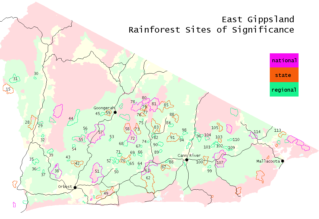
Of the 124 Rainforest Sites of Significance (RSOS) in East Gippsland, only a third of these sites are protected within dedicated conservation reserves. The rest of these sites are either fully or partially within State Forest and threatened by current clearfell logging practices. (Note: RSOS that are wholly within dedicated reserves such as National Parks have not been the focus of this study as they are assumed to be protected from the threat of clearfell logging.)
For more information about the threats to RSOS see issues listed on the left of this webpage.
The map and list below is connected to a database that provides a profile of all RSOS that are partially or totally within State Forest in East Gippsland (numbered sites).
RSOS are colour coded as National, State and Regional.
Download East Gippsland RSOS overlay![]()
or
Click on map or list (below) to get a profile for each threatened RSOS.
| Site | RSOS Name | Ranking | Logging |
| 15 | Ah Chow Creek. Timbara Gorge | State | |
| 28 | Mt Dawson - Plum Gully | State | |
| 29 | Murrindal | Regional | |
| 30 | Mt Statham | Regional | |
| 31 | Mellick Munjie-Eaglehawke Ck(Tambo) | Regional | |
| 32 | Mt McLeod | Regional | |
| 35 | Tara Range | Regional | |
| 36 | Wombat Creek/Mottle Range | Regional | |
| 37 | Tucker Box Track | Regional | |
| 38 | Lower Snowy | National | |
| 39 | Rocky Creek | Regional | |
| 42 | Mt Buck | State | |
| 43 | Silvertop Hill | Regional | |
| 44 | Yalmy Sidecut** | Regional | |
| 45 | Little Yalmy River | Regional | |
| 49 | Cabbage Tree Creek | State | |
| 50 | Dryers Creek | Regional | |
| 51 | Brobribb River | National | |
| 52 | Murrungowar | Regional | |
| 53 | Rich River Headwater | Regional | |
| 54 | Mt Pinnak | Regional | |
| 55 | Sardine- Paridise Ridge | Regional | |
| 56 | Riddle Creek | Regional | |
| 57 | Martins Creek | National | |
| 58 | Big River*** | State | |
| 59 | Mt Jersey | State | |
| 60 | Ellery Creek (This one now safe) | Regional | |
| 62 | Lower Bemm | State | |
| 63 | Bemm River | National | |
| 64 | Mt Billy, McKenzie River | Regional | |
| 65 | Pheasant Creek | Regional | |
| 66 | Mt Puggaree | Regional | |
| 67 | Goolengook River (VEAC) | Regional | |
| 68 | Little Arte River | Regional | |
| 69 | Arte River Falls | Regional | |
| 70 | Glen Arte | State | |
| 71 | Mt Tanglefoot | Regional | |
| 72 | Little Goolengook (VEAC) | National | |
| 73 | Upper Goolengook (VEAC) | State | |
| 74 | Suzuki (Blackwatch Track) | Regional | |
| 75 | St Johns Creek | Regional | |
| 76 | Kanuka Creek | State | |
| 77 | West Errinundra River | State | |
| 78 | Cobb Hill | National | |
| 79 | Sassafrass Basin | State | |
| 80 | Goonmirk Rocks | National | |
| 81 | East Errinundra | National | Threat of imminent logging |
| 82 | Combienbar River | Regional | |
| 83 | Bungywarr Ck | State | |
| 84 | Clays Cresent | Regional | |
| 85 | Hensleigh/Quadra | State | |
| 86 | Three Sisters | State | |
| 87 | Serpentine Ck | State | |
| 88 | Sydd Ck | Regional | |
| 89 | Pyramid Hill | Regional | |
| 90 | Pyramid Ck-Tongi Swamp CK | Regional | |
| 91 | Upper Tonghi (Tonghi Jungle - Walderon Mts) | State | |
| 92 | Cann River Flats (Private land) | Regional | |
| 93 | Cann River Flats (Private land) | Regional | |
| 94 | Jim Walker CK | Regional | |
| 95 | Cann River Flats (Private land) | Regional | |
| 96 | Log Bridge Ck | Regional | |
| 97 | Cann River Flats (Private land) | Regional | |
| 98 | Kate Ck - Cann Mt | Regional | |
| 99 | Lomond Hill | Regional | |
| 100 | Thurra Crossing on HWY | Regional | |
| 101 | Brown Ck Future trail | Regional | |
| 102 | Brown Ck Thurra River Rd | Regional | |
| 103 | Mt Future (Peel Upgrade) | State | |
| 104 | Black Snake Ck | Regional | |
| 105 | East Thurra | Regional | |
| 107 | Mt Drummer | National | |
| 109 | Scrubby ck | Regional | |
| 110 | Upper Wingan | Regional | |
| 113 | Royd Ck | State | |
| 114 | Genoa | National |