Dingo Creek (Sellers Road) forest blockade
Also on this page:
Protest History
Logging shown to be unlawful
VRN Influence in Government Processes
Links to other websites
Location and Values
Dingo Creek is a 380ha area of State forest to the north east of the Errinundra National Park. If forms the headwater of the Queensborough River.
Dingo creek is the only part of the East Errinundra National Rainforest Site of Significance (RSOS 81) which is currently not in the Errinundra National Park. The parts of RSOS 81 that are within the National Park contain the single biggest stand of Cool Temperate Rainforest in Victoria. The area also has significant old growth wet forests, provides habitat for endangered Sooty and Powerful owl and has extensive stands of Cool Temperate rainforest.
In November 2006 the Victorian State Government nominated Dingo Creek as an icon area to be added to the Errinundra National Park.
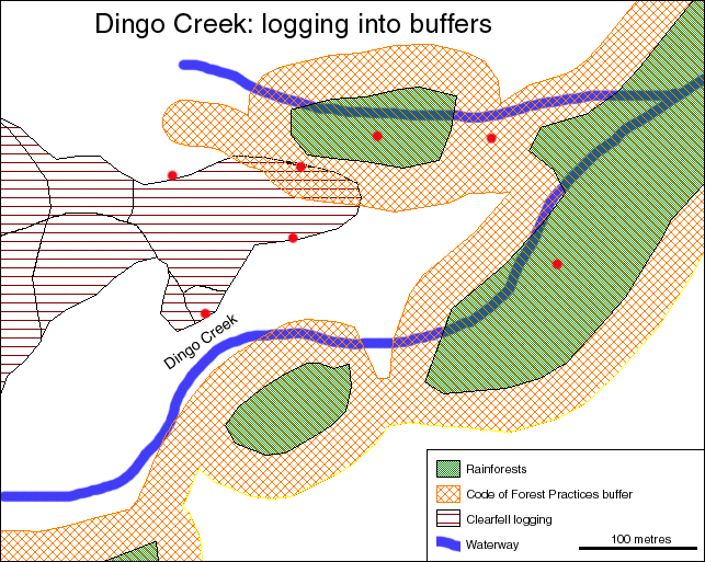
Map of Dingo Creek
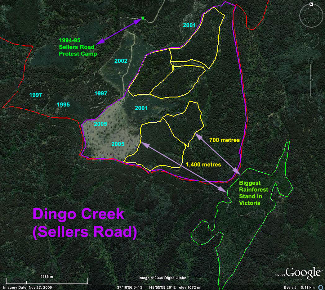 Click map to enlarge. (This image was taken the day after the 2006 State Election.)
Purple line = Dingo Creek icon area to be protected.
Yellow line = Coupes that will now not be clearfell logged .
Red line = National Park Boundry.
Green line = Biggest rainforest stand in Victoria.
Year = Year different areas were clearfell logged.
Currently Dingo Creek area is made up of a:
- 260ha Special Management Zone(SMZ) 843/01 that allowed logging.
- 120ha Special Protection Zone(SPZ) 843/05 defined in the East Gippsland Management Plan as having old growth wet forest values and habitat for the Powerful Owl where logging was not permitted.
According to the SMZ Plan the intention was to clearfell log about eight coupes. The average size of each coupe is about 20ha.
As shown on the map above, three coupes (approximately 61.5 ha or 16% of the total area iniside the purple line) was clearfell logged in the north west corner since 2001.
Dingo Creek is a critical buffer needed to help protect Victoria's largest stand of rainforest from wildfire (See wildfire case study). The remaining five coupe that will now not be logged (170ha gross area) are strategically positioned to act as a large rainforest buffer. If logging continued as originally planned, the rainforest forest buffer would only be 700 meters. The Government commitment to protect Dingo creek doubles this buffer to at least 1.4 km. (See map above).
Protest History
Conservationists first took an interest in protecting the Dingo Creek area in 1994. Back then the area was known as the Sellers Road blockade. In February 1994, the logging industry was trying to extend Sellers Road into the Dingo creek area which until then was wilderness.
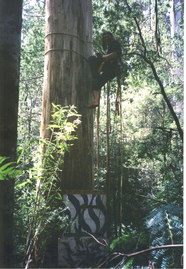
On 14 February 1994 the first protest occurred. Forest activists attempted to stop Sellers Road being constructed across the headwaters of the Queensborough river. This protest marked the very first tree-sits to ever be raised in East Gippsland.
 |
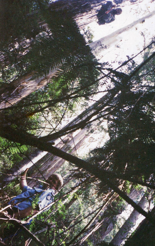 |
Click to enlarge: 14 Feburary 1994. LH Photo: First tree sit and tree climber in East Gippsland who was trying to obstuct road building what was to become Sellers Road. RH Photo: Police officer nicknamed 'Stick' was unable to arrest the protestor above him.
Four people were arrested in a diversion action designed to distract the government road builders and police so tree sitters had extra time to set up.
The protestors failed to stop the Sellers road extension. In defiance, a permanent protest camp was set up shortly afterwards on the newly constructed bridge (large culvert under road. See map above for camp location).
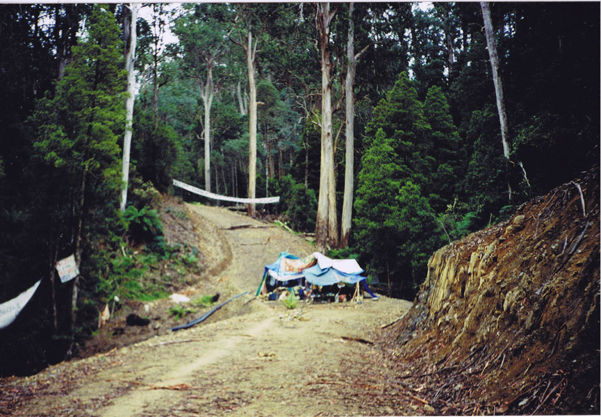 Click to enlarge: Sellers road protest camp 1994 - 1995.
This camp was maintained as a continuous presence until November 1995 when police removed it so logging could commence. From 1995 to 2005 nine areas were clearfell logging along the new road. (See map above of areas logged.)
For every logging coupe(nine) there was protest action or conservationists arrested trying to protect the area.
Logging shown to be unlawful
In 2000-2001 logging began in the SMZ area that was to become known as Dingo Creek. One protestor arrested began to argue in court (on his own initiative) that the logging authorised by the Government at Dingo creek was in breach of the Code of Forest Paractices and unlawful.
Click on interactive map to see photos of illegal logging.
The protestor argued in court that loggers had failed to apply rainforest buffers as outlined in the Code of Forest Practices for Timber Harvesting. After 5 years in the courts, a Supreme Court Judge found that the 2001 logging was unlawful and changes against the protestor were dropped. See Tony Quolls webpage about this mammoth court case and ABC radio 2005.
(Note: A similar example of protesters changes being dismissed by the Courts occured in the Otways in 2003 for a protest that occured in 2001 at Ciancio creek near rainforest. See more on OREN website.)
VRN Influence in Government Processes
In 2005 a review of the 1996 Code of Forest Practice for Timber Harvesting began. VRN began to lobby and wrote submissions focusing on the ambiguity with respect to rainforest prescriptions contained within the 1996 Code. The ambiguity allowed logging when the intention was for National Rainforest Sites of Significance to be protected.
Unfortunately during the Code Review process, another 40ha was clearfell logged at Dingo Creek by VicForests from March to November 2005. More people were arrested trying to stop the logging (See GECO webpage).
DSE acknowledged that maybe they should not be logging at Dingo Creek while the Code Review process was occuring. (See DSE letter last paragraph on first page.)
Sure enough in early 2006 a revised draft Code recognised that the intent of the 1996 Code was to ban logging in core rainforest Sites of National Significance.
The Victorian government made maps available to VRN in March 2006 that show where the protected area at Dingo creek would occur. (shown in purple). (You can see maps for all National RSOS here.)
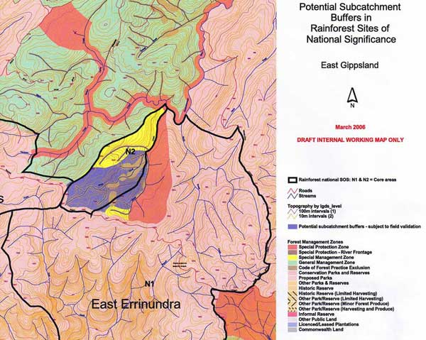 The purple area on this map is the area the Victorian State Government conceded (in early 2006) should not be logged to protect Nationally Signifcant Rainforest. However the western half had already been logged (60ha).
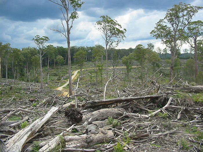 Looking west. This area was clearfell logged at Dingo Creek in 2005 during the Code Review process (see map above for location). Four months after logging finished here the draft revised Code of Forest Practices was released and recommended protection of this area.
The retained forest in the background is the boader of the existing Errinundra National Park.
During the Steedman and Gooding assessment for East Gippsland, VRN raised these issues and the history surrounding Dingo creek.
In recognition of the environmental values and long running conflict at Dingo creek, the ALP State Government announced during the November 2006 State election that all remaining Dingo Creek forests would be added to the Errinundra National Park.
This protection was offered more than 12 years after the first protests. A total of eight coupes had been logged beyond the original 1994 protest camp however five coupes are now to be saved from logging.
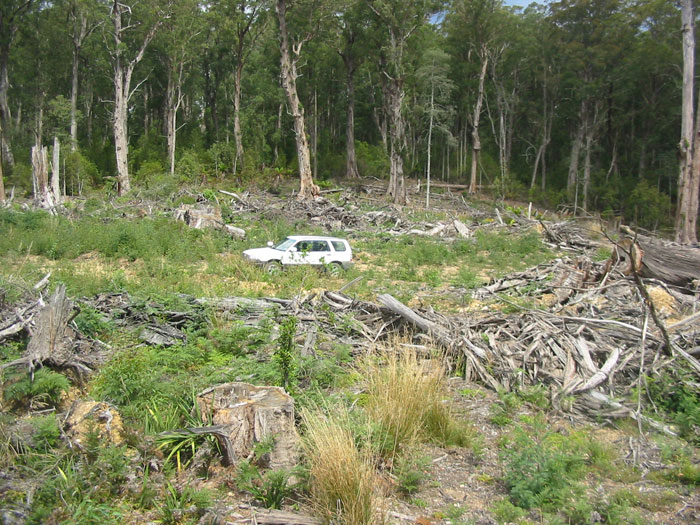 Looking East. The car is in the area clearfell logged in 2005. The standing trees behind were going to be cut down as the next logging coupe. This whole area is now protected from logging by prescriptions. In the future this area will be made National Park.
In June 2009 a new Rainforest Actions Statement was released as a part of Flora and Fauna Guarantee Act. This Action Statement has clear prescriptions that ban logging in National RSOS 81. It is now unlawful to log at Dingo creek as it is a legal requirement of the new 2007 Code of Forest Practices to follow the prescriptions set out in the Rainforest Action Statement.
Although Dingo Creek is protected from logging by prescriptions contained within Codes of logging practice, the most secure long term protected will only be offered by inclusion within the Errinundra National Park.
Dingo creek (Sellers Road)
Protest Websites
GECO webpages: Archive webpages from 2001 and 2005 lots of photos and campaign details.
Tony Quoll website: Includes photos taken 2001 and 2005 and lots more.